


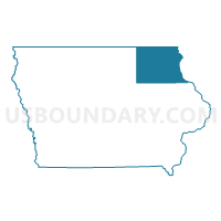
Bremer, Winneshiek, Fayette, Clayton, Allamakee, Chickasaw & Howard Counties PUMA, Iowa
About
Outline

Summary
| Unique Area Identifier | 192922 |
| Name | Bremer, Winneshiek, Fayette, Clayton, Allamakee, Chickasaw & Howard Counties PUMA |
| State | Iowa |
| Area (square miles) | 4,291.57 |
| Land Area (square miles) | 4,251.40 |
| Water Area (square miles) | 40.16 |
| % of Land Area | 99.06 |
| % of Water Area | 0.94 |
| Latitude of the Internal Point | 43.06293190 |
| Longtitude of the Internal Point | -91.83246150 |
Maps

Graphs
Select a template below for downloading or customizing gragh for Bremer, Winneshiek, Fayette, Clayton, Allamakee, Chickasaw & Howard Counties PUMA, Iowa


Neighbors
Neighoring Public Use Microdata Area (by Name) Neighboring Public Use Microdata Area on the Map
- Black Hawk County--Waterloo & Cedar Falls Cities PUMA, IA
- Cerro Gordo, Floyd, Kossuth, Hancock, Winnebago, Mitchell & Worth Counties PUMA, IA
- Dubuque, Buchanan, Jackson & Delaware Counties--Dubuque City PUMA, IA
- Grant, Green, Iowa, Richland & Lafayette Counties PUMA, WI
- Mower, Steele, Freeborn & Dodge Counties PUMA, MN
- Webster, Hardin, Hamilton, Butler, Wright, Grundy, Franklin & Humboldt Counties PUMA, IA
- West Central Wisconsin--Northern Mississippi Region PUMA, WI
- Winona, Wabasha, Fillmore & Houston Counties--Winona City PUMA, MN
Top 10 Neighboring County (by Population) Neighboring County on the Map
- Black Hawk County, IA (131,090)
- Dubuque County, IA (93,653)
- Grant County, WI (51,208)
- Mower County, MN (39,163)
- Vernon County, WI (29,773)
- Bremer County, IA (24,276)
- Winneshiek County, IA (21,056)
- Buchanan County, IA (20,958)
- Fayette County, IA (20,880)
- Fillmore County, MN (20,866)
Top 10 Neighboring County Subdivision (by Population) Neighboring County Subdivision on the Map
- Decorah township, Winneshiek County, IA (10,040)
- Waverly city, Bremer County, IA (9,874)
- Jefferson township, Fayette County, IA (6,910)
- Vernon Springs township, Howard County, IA (4,540)
- Makee township, Allamakee County, IA (4,176)
- Jefferson township, Bremer County, IA (3,148)
- New Hampton township, Chickasaw County, IA (2,928)
- Jefferson township, Clayton County, IA (2,624)
- West Union city, Fayette County, IA (2,486)
- Monona township, Clayton County, IA (2,225)
Top 10 Neighboring Place (by Population) Neighboring Place on the Map
- Waverly city, IA (9,874)
- Decorah city, IA (8,127)
- Oelwein city, IA (6,415)
- Waukon city, IA (3,897)
- Cresco city, IA (3,868)
- New Hampton city, IA (3,571)
- West Union city, IA (2,486)
- Postville city, IA (2,227)
- Sumner city, IA (2,028)
- Guttenberg city, IA (1,919)
Top 10 Neighboring Unified School District (by Population) Neighboring Unified School District on the Map
- Dubuque Community School District, IA (75,725)
- Western Dubuque Community School District, IA (21,320)
- Waverly-Shell Rock Community School District, IA (13,798)
- Decorah Community School District, IA (11,998)
- Charles City Community School District, IA (11,362)
- Howard-Winneshiek Community School District, IA (9,186)
- Oelwein Community School District, IA (9,134)
- Allamakee Community School District, IA (8,992)
- Prairie du Chien Area School District, WI (8,669)
- New Hampton Community School District, IA (6,942)
Top 10 Neighboring State Legislative District Lower Chamber (by Population) Neighboring State Legislative District Lower Chamber on the Map
- Assembly District 96, WI (55,740)
- Assembly District 49, WI (55,522)
- State House District 27B, MN (37,406)
- State House District 31B, MN (35,692)
- State House District 32, IA (30,747)
- State House District 19, IA (29,974)
- State House District 17, IA (29,880)
- State House District 16, IA (29,039)
- State House District 23, IA (28,807)
- State House District 14, IA (28,299)
Top 10 Neighboring State Legislative District Upper Chamber (by Population) Neighboring State Legislative District Upper Chamber on the Map
- State Senate District 17, WI (172,391)
- State Senate District 32, WI (172,379)
- State Senate District 31, MN (73,030)
- State Senate District 27, MN (72,647)
- State Senate District 16, IA (62,654)
- State Senate District 10, IA (62,481)
- State Senate District 9, IA (58,130)
- State Senate District 8, IA (57,073)
- State Senate District 12, IA (56,900)
- State Senate District 7, IA (56,350)
Top 10 Neighboring 111th Congressional District (by Population) Neighboring 111th Congressional District on the Map
- Congressional District 3, WI (729,957)
- Congressional District 1, MN (644,787)
- Congressional District 4, IA (609,487)
- Congressional District 1, IA (596,443)
Top 10 Neighboring Census Tract (by Population) Neighboring Census Tract on the Map
- Census Tract 26.03, Black Hawk County, IA (10,029)
- Census Tract 9502, Winneshiek County, IA (6,008)
- Census Tract 46, Bremer County, IA (4,876)
- Census Tract 9504, Winneshiek County, IA (4,673)
- Census Tract 13, Mower County, MN (4,577)
- Census Tract 26.04, Black Hawk County, IA (4,154)
- Census Tract 9603, Allamakee County, IA (4,088)
- Census Tract 9502, Buchanan County, IA (4,054)
- Census Tract 9607, Vernon County, WI (4,017)
- Census Tract 9601, Howard County, IA (3,993)
Top 10 Neighboring 5-Digit ZIP Code Tabulation Area (by Population) Neighboring 5-Digit ZIP Code Tabulation Area on the Map
- 50613, IA (42,031)
- 50703, IA (19,863)
- 52101, IA (13,864)
- 50677, IA (12,131)
- 50616, IA (10,344)
- 53821, WI (8,456)
- 50662, IA (7,238)
- 52172, IA (6,303)
- 52136, IA (5,967)
- 50659, IA (5,488)